

Segmann - Salzach glacier
At the peak of the Würm ice age, 24-22,000 years ago, around 150,000 sq. km. of the Alps and foothills were covered in ice. The valleys and were filled with ice up to 2,000 m thick, such as the Inn glacier, Salzach glacier and Traun glacier.
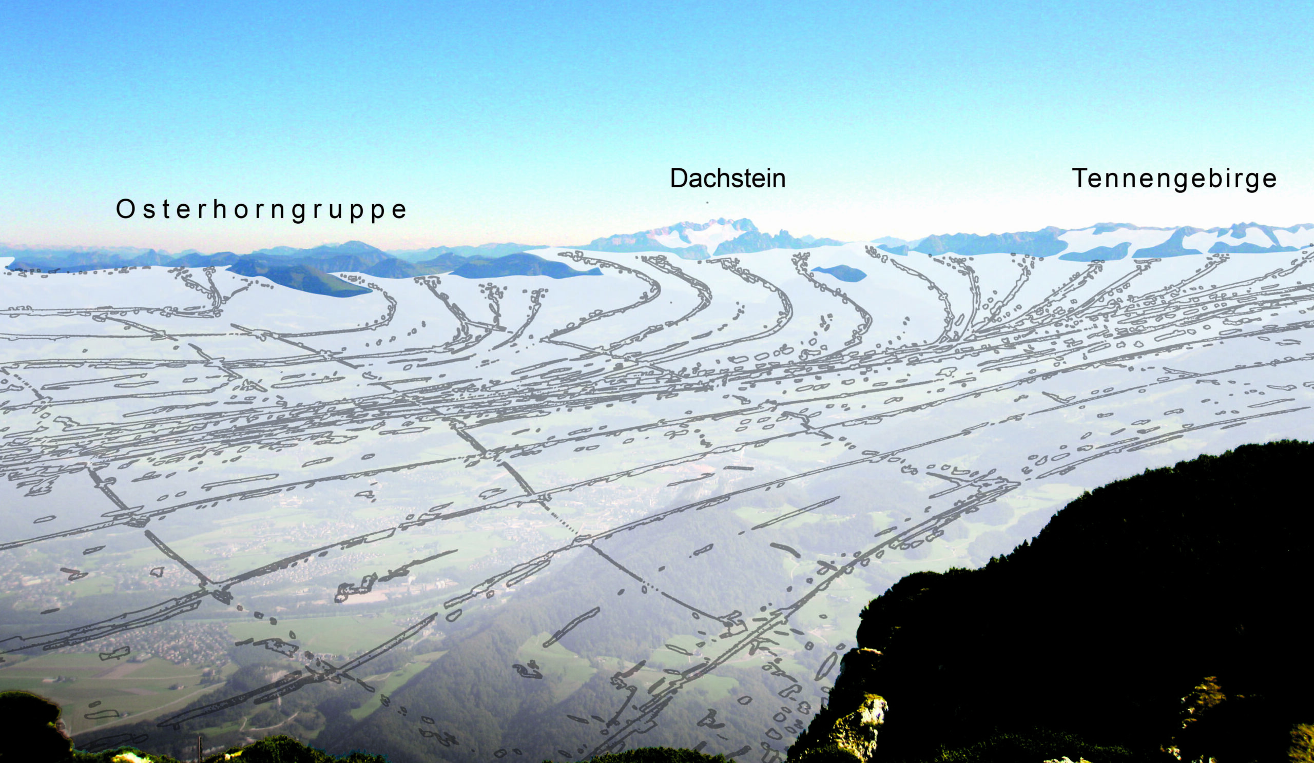
At the peak of the Würm ice age, the Salzach glacier covered an area of 6,8000 sq. km. The boundaries of the catchment area were formed by the Gerlos pass in the west, the main alpine ridge in the south, and the Wagrainer pass in the east. From the catchment area, the north slope of the Hohe Tauern, ice streams followed the Tauern valleys, joined together in the Salzach valley and flowed northward through this region and the Saalach valley. In the area of the Ore of the Alps UNESCO Global Geopark, the upper limit of the ice was 2,000; in the area of the city of Salzburg, it was 1,000.
The two ice streams merged in the Salzburg Basin, in the area of the city of Salzburg. From here, the ice masses formed a common foreland glacier (Piedmont glacier) in the Salzburg-Bavarian border area. This fanned out into several glacial branches, the edges of which encompassed terminal moraines. The interior of the branch basin is still characterized today by a gently undulating ground moraine landscape.
Kids
What are glaciers?
Glaciers are thick masses of ice on land that have formed over hundreds or thousands of years. Unlike snow, which melts in spring, glacier ice is present all year round! This is why glaciers are only found in the coldest regions, such as the North and South Poles and in very high mountains such as the Alps and the Himalayas.
Glaciers may look like immobile, huge blocks of ice, but in reality they are frozen rivers that flow very slowly and rub against the ground. Glaciers are so powerful that they can carve out valleys and hills and transport large blocks of rock over long distances! In fact, the Salzach Valley, where Bischofshofen is located, and the surrounding hills of Hochgründeck and Hochkeil were formed by ice-age glaciers!
Glaciers form some of the most beautiful landscapes on earth. However, for the flora and fauna in the mountains and for human communities such as the Amu Darya in Central Asia, glaciers are also an important source of fresh water for drinking and irrigating fields. In the polar regions, glaciers are a habitat for many animals.
What are glaciers?
Glaciers are thick masses of ice on land that form over hundreds or thousands of years through the accumulation, compaction and recrystallisation of snow. They are not to be confused with the sea ice that forms over the Arctic and Antarctic oceans.
Unlike normal snow, which melts in spring, glacier ice is present all year round. This is why glaciers are only found in the coldest regions of the world, such as the North and South Poles, and in very high mountain ranges such as the Alps and the Himalayas. They can even form near the equator, but only at extremely high altitudes such as Mount Kilimanjaro in Tanzania, whose summit is 5895 metres above sea level.
Glaciers are divided into two main types: Ice sheets or continental glaciers cover large areas such as that of Greenland and Antarctica, while valley or alpine glaciers are relatively small. As the name suggests, alpine glaciers form in former river valleys in mountainous regions that are bordered on both sides by rock faces.
Glaciers may look like immobile, huge blocks of ice, but in reality they are frozen rivers that flow very slowly and slide against the ground. The layers of ice within the glacier are also in motion, sliding over each other. When glaciers move, they can scrape the surface and pull large boulders and other materials out of the ground and transport them great distances! When a glacier melts and deposits these materials, they are called boulder clay or till. Till often looks chaotic as it is a mixture of different rock types and sizes.
Glaciers are perhaps the most powerful erosion factor. They can shape entire landscapes and form characteristic features such as U-shaped valleys, depressions that can be filled with lakes and elongated, polished hills. The Salzach Valley, in which Bischofshofen is located, and the surrounding rounded hills of Hochgründeck and Hochkeil were also shaped by the glacial movements of the last ice ages!
Glaciers form some of the most beautiful landscapes on earth. However, for the flora and fauna in the mountains and for human communities such as the Amu Darya in Central Asia, glaciers are also an important source of fresh water for drinking and irrigating fields. In the polar regions, glaciers are a habitat for many animals.
What are glaciers?
Glaciers are thick masses of ice on land that form over hundreds or thousands of years through the accumulation, compaction and recrystallisation of snow. They are not to be confused with the sea ice that forms over the Arctic and Antarctic oceans!
Unlike normal snow, which melts in spring, glacier ice is present all year round. This is why glaciers are only found in the coldest regions of the world, such as the North and South Poles, and in very high mountain ranges such as the Alps and the Himalayas. They can even form near the equator, but only at extremely high altitudes such as Mount Kilimanjaro in Tanzania, whose summit is 5895 metres above sea level!
Glaciers can be divided into two main types: Ice sheets or continental glaciers cover large areas such as that of Greenland, while valley or alpine glaciers are relatively small. As the name suggests, alpine glaciers form in former river valleys in the mountains, which are bordered on both sides by rock faces.
Glaciers may look like immobile, huge blocks of ice, but in reality they are frozen rivers that move very slowly. The mechanism of this slow movement is complex because the behaviour of the ice depends on the amount of pressure exerted on it. Crevasses often form in the upper parts of glaciers because the tension is low and the ice breaks. Inside the glacier, however, thick accumulations of ice exert a pressure that exceeds the threshold. Instead of breaking, these layers behave like plastic, flowing and sliding over each other. At the base of the glacier, a different kind of movement takes place, with the lowest parts sliding across the ground - a process known as basal sliding. The movement within and at the base of the glacier carries the upper part with it.
Glaciers are powerful erosive forces that are capable of transporting large quantities of debris. As they flow, glaciers tear huge blocks of rock and other materials out of the ground and transport them over long distances. When a glacier melts and deposits these materials, they are called boulder clay or till. Till often looks chaotic as it is a mixture of different rock types and sizes.
The erosion of glaciers shapes the land they cross, as the debris they carry acts like sandpaper and abrades the surface. Through erosion and deposition, the glaciers form characteristic features such as U-shaped valleys, depressions that are now filled with lakes and elongated, polished hills and the surrounding hills of Hochgründeck and Hochkeil were shaped by the glacial movements of the last ice ages.
Glaciers form some of the most beautiful landscapes on earth. But they are not only of aesthetic value. Glaciers are the largest freshwater reservoirs on earth. For the flora and fauna in the mountains and for human communities such as the Amu Darya in Central Asia, glacier melt is an important source of fresh water for drinking and irrigating fields. When this glacial melt reaches the sea, it provides abundant nutrients for marine plankton. In the polar regions, glaciers are also a habitat for many animals.
